The C-MAP 4D is a state-of-the-art electronic marine chart that propels maritime navigation into a new realm of precision and reliability. Distinguished for its dynamic features, the C-MAP 4D system is designed to evolve with the latest technological innovations, allowing boaters to incorporate new data and services as soon as they're released.
Ensuring wide-ranging compatibility, the C-MAP 4D chart is designed to work seamlessly with a variety of chartplotters, including the Furuno 1670F / 1870F, and Standard Horizon CPN 7000i, and CPN1010i units. This interoperability makes it a sought-after navigation solution for a broad spectrum of seafaring vessels, from leisure yachts to professional fishing boats.
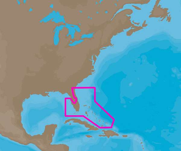
Specifically, the C-MAP 4D NA-D943 variant provides exhaustive nautical chart details for the coastal regions of Florida and the entire archipelago of The Bahamas. This means boaters navigating these popular and sometimes challenging waters will have access to the most current and comprehensive chart data available.
Boasting a suite of advanced features, C-MAP 4D charts empower mariners with an enhanced layer of confidence and control. Below is a list of notable features that users can expect from the C-MAP 4D NA-D943 package:
- High-Resolution Bathymetric Data: Precise contours and depth soundings for fishermen and divers looking to find the best spots or to navigate safely in shallow waters.
- Dynamic Raster Charts: Traditional paper chart look with the ability to access detailed information on specific chart objects.
- 3D Views: Perspective views of land elevation and underwater topography, ideal for planning routes and understanding the seabed structure.
- Satellite Images: Enhanced situational awareness with aerial photographs of ports, marinas, bridges, and navigational landmarks.
- Easy Routing: Automatically plots the safest and shortest route based on detailed chart data and user-defined vessel information.
- Marine Protected Areas: Information on conservation areas or restricted zones to ensure compliance with regional regulations.
- : Integration of live weather and tidal data to plan for the safest journey possible.
- Updating Service: Opportunity to update charts with the latest notices to mariners, ensuring the most accurate and current navigation data.
FAQs
Q: What are the advanced features of the C-MAP 4D?
A: The C-MAP 4D is equipped with several advanced features including 3D View, High-Resolution Bathymetric Data, Easy Routing, and access to Dynamic Raster Charts and Satellite Imagery, among others.
Q: Which devices is the C-MAP 4D compatible with?
A: The C-MAP 4D is compatible with Furuno 1670F / 1870F, and Standard Horizon CPN 7000i, and CPN1010i units, catering to the needs of diverse maritime applications.
Q: What areas does the C-MAP 4D NA-D943 chart cover?
A: The C-MAP 4D NA-D943 chart provides exhaustive coverage of Florida and The Bahamas, delivering an unparalleled navigation experience in these regions.





Skylar –
Sam –
Amador –
Marcos –
Zebulon –