

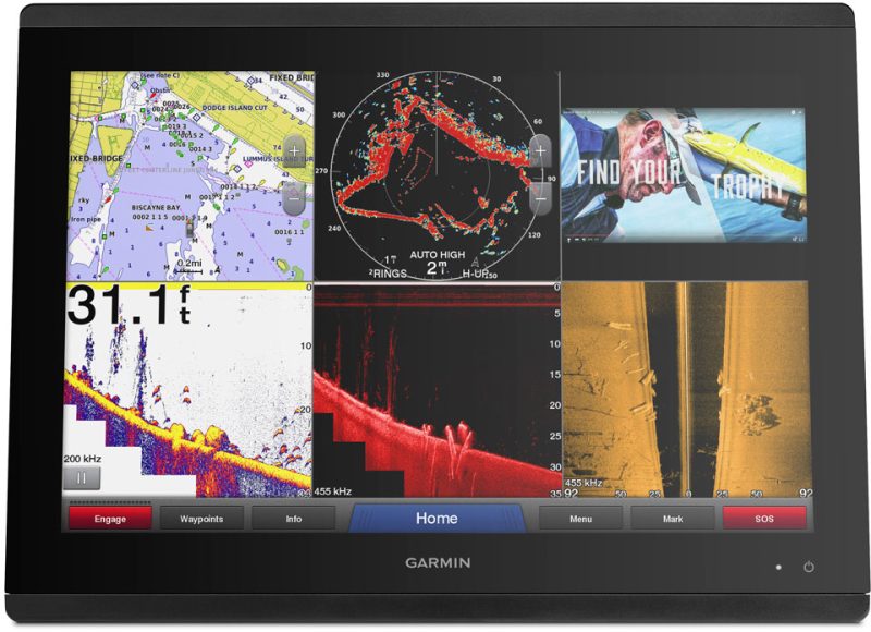
The Garmin HXUS030R BlueChart g2 HD is a navigation map that covers the Southeast Caribbean region. It includes Haiti, Trinidad and Tobago, Puerto Rico, and the entire Lesser Antilles. In addition, it also covers the Colombian and Venezuelan beaches from Barranquilla to the mouth of the Orinoco River, including Lake Maracaibo and the Gulf of Paria.
This map is an advanced chart provider that combines data from government charts and private sources. It offers various navigational aids such as spot soundings, depth contours, tides and currents, as well as detailed information on ports and marinas.
The Depth Range Shading feature allows users to easily visualize their desired depth level, with up to ten different depth ranges displayed. This is particularly useful for fishing and navigating in areas such as swamps, canals, and marinas.
The Shallow Water Shading function provides depth shading at a user-defined level, making navigation easier in shallow waters.
Detailed maps are also included in this chart, allowing mariners to confidently navigate their boats in and out of ports.
With 1-foot contours, BlueChart g2 HD provides a more accurate representation of bottom structures for fishing charts and better detail in swamps, canals, and port designs.
It is important to note that this product may contain chemicals that are known to the state of California to cause cancer, birth defects, and other reproductive harm.
Frequently Asked Questions
1. Can I use this map on any Garmin device?
Yes, you can use the Garmin HXUS030R BlueChart g2 HD on any Garmin device that supports the BlueChart g2 HD format.
2. Does this map include detailed information on ports and marinas?
Yes, this map provides detailed information on ports and marinas, allowing you to navigate with confidence.
3. Can I customize the depth ranges displayed on the map?
Yes, the Depth Range Shading feature allows you to customize the depth ranges displayed, with up to ten different depth levels.
4. Is the Shallow Water Shading function available in this map?
Yes, the Shallow Water Shading function is available, providing depth shading at a user-defined level in shallow waters.
5. What level of detail does this map provide?
This map provides 1-foot contours, offering a more accurate representation of bottom structures for fishing charts and better detail in swamps, canals, and port designs.


Stevie –