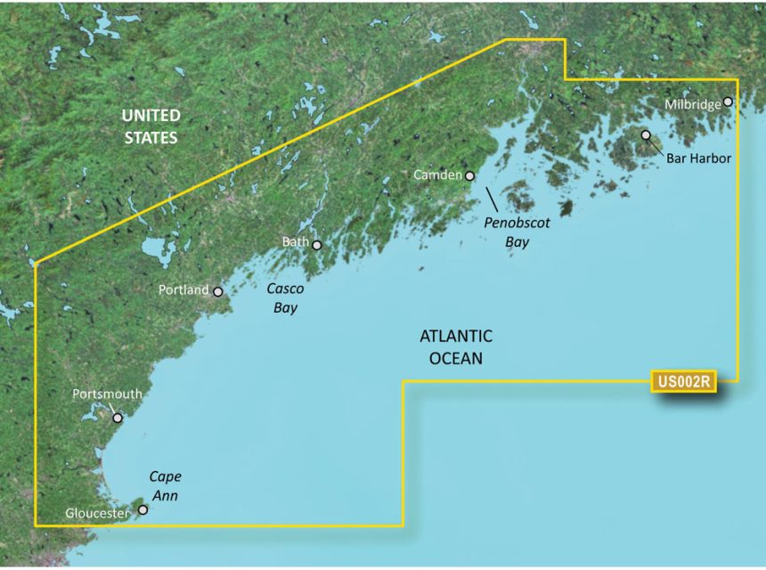
The Garmin VUS002R BlueChart g3 Vision HD is a premium navigation chart targeting mariners and boating enthusiasts who traverse the coastal areas of South Maine. It is delivered on a microSD/SD card combination, offering up-to-date nautical data, as well as innovative features for enhanced navigation and fishing.
Here are some of the cutting-edge features that the BlueChart g3 Vision HD offers:
- Auto Guidance Technology: This feature simplifies route planning by automatically suggesting the best paths based on factors like boat size, depth, and overhead clearance.
- High-Resolution Relief Shading: Combining color and shadow, this provides a more life-like representation of the ocean floor to improve the understanding of the underwater structure.
- NOAA Raster Cartography: Get an at-a-glance understanding of chart data with a traditional paper chart look, making it familiar and easy to read.
- Depth Range Shading: This distinguishes between different depth regions with varied shading, allowing for quick and easy identification of target depths.
- Shallow Water Shading: Set a minimum depth and have all areas shallower than your setting shaded for heightened situational awareness.
- High-Resolution Satellite Imagery: Gain a clear, above-water line of sight with overhead satellite images that can help you navigate more confidently.
Although the Garmin VUS002R BlueChart g3 Vision HD is a powerful tool for navigation planning, it is essential to remember that it should be used in conjunction with other safe navigation practices, and is not a substitute for personal judgments or local knowledge required when on the water.
It's also worth noting that while the raster cartography features are not available on some specific devices like the echoMAP CHIRP and ECHOMAP Plus combinations, they are accessible on mobile devices through the ActiveCaptain mobile app. This versatility ensures that users can enjoy the benefits of g3 Vision HD charting on their preferred devices, whether on dedicated displays or their personal smart devices.
For individuals deeply involved in marine activities such as navigating unfamiliar coasts, inland waterways, or engaged in serious fishing, the Garmin VUS002R BlueChart g3 Vision HD offers detailed cartographic information and an array of features that bring a heightened level of confidence and enjoyment to the experience on the water.
Frequently Asked Questions
1. Can the BlueChart g3 Vision HD be used for navigation planning?
Yes, the BlueChart g3 Vision HD can be utilized for comprehensive planning purposes but is not intended to replace safe navigation practices and local knowledge.
2. How does Auto Guidance technology work?
Auto Guidance technology streamlines the process of route planning by using the boat's dimensions, as well as chart data on depth and overhead clearance to suggest the best navigable paths.
3. What is the benefit of high-resolution relief shading?
High-resolution relief shading integrates intricate shading and colors to bring a detailed 3D perspective of the ocean floor terrain, amplifying navigational awareness for the user.
4. Are the raster cartography features available on all devices?
No, the raster cartography features are not included on all devices, specifically the echoMAP CHIRP and ECHOMAP Plus combos, but they are available on mobile devices through the ActiveCaptain app.
5. What additional features does the g3 Vision HD include?
The g3 Vision HD is enhanced with several additional features such as NOAA Raster Cartography, depth range shading, shallow water shading, and high-resolution satellite imagery, each contributing to superior clarity and coverage of maritime data and charts.






Sarrah –
Chi –
Autum –