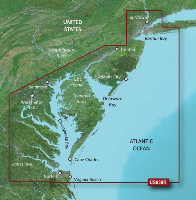
The Garmin VUS038R BlueChart g3 Vision HD is a state-of-the-art navigation aid tailored to the needs of boaters voyaging between New York and the Chesapeake Bay. By integrating the most reliable data from Garmin and Navionics, it offers unparalleled chart detail and clarity.
Here are some key **features** of the Garmin VUS038R:
- Auto Guidance Technology: This advanced system assists in route planning by suggesting the safest and most efficient paths for navigation.
- High-Resolution Relief Shading: Enhanced contouring provides a vivid depiction of the seabed, allowing for improved hazard identification and undersea terrain awareness.
- Depth Range Shading: Users can set up different shades for various depth ranges, which is crucial for recognizing target depths when fishing or looking for anchorages.
- Shallow Water Shading: This safety feature offers a quick visual reference for shallow areas to be navigated with extra caution.
- High-Resolution Satellite Imagery: Aerial photos give real-world references for navigators, aiding in the recognition of landforms and marinas.
- NOAA Raster Cartography Integration: Via the ActiveCaptain app, boaters can access NOAA's detailed maritime charts, which include critical points of interest.
- MarineEye and FishEye Views: Distinct 3-D perspectives both above and below the waterline enrich the navigational experience by offering a comprehensive view of the environment.
Whether you're fishing, sailing, or cruising, the Garmin VUS038R provides an edge with its innovative navigational features. However, it's vital to understand that while Auto Guidance can serve as a powerful planning tool, it doesn't replace the necessity for prudent seamanship and situational awareness.
Regarding compatibility, certain features such as the NOAA Raster Cartography are not viewable on the echoMAP CHIRP and ECHOMAP Plus combos but are available through the compatible ActiveCaptain mobile app, expanding accessibility beyond the confines of dedicated marine hardware.
Frequently Asked Questions
1. Can the Garmin VUS038R calculate routes and suggest paths?
Yes, the Garmin VUS038R BlueChart g3 Vision HD is equipped with Auto Guidance technology to calculate routes and offer path suggestions.
2. Does the device offer high-resolution relief shading?
Absolutely, the device boasts high-resolution relief shading for enhanced visualization of the seafloor landscape.
3. Can I access detailed images of ports and marinas?
Yes, with the Garmin VUS038R, users can download NOAA Raster Cartography2 on the ActiveCaptain app for detailed imagery of ports, marinas, bridges, and other navigational points of interest.
4. Are there 3-D views available?
Indeed, the Garmin VUS038R features 3-D views such as MarineEye and FishEye, offering enriched perspectives above and beneath the waterline.
5. Can I view raster cartography on the echoMAP CHIRP and ECHOMAP Plus combos?
No, raster cartography is not viewable on the echoMAP CHIRP and ECHOMAP Plus series. However, these detailed maps can be accessed on mobile devices through the ActiveCaptain mobile app.



Aleta –
Kisha –
Keyonna –
Marcus –
Celena –