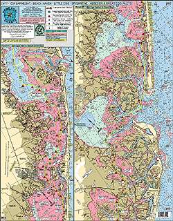
Home Port Chart 11 is a comprehensive chart that includes the entire Mullica River, making it ideal for kayaking. It also covers various inlets such as Barnegat, Beach Haven, Little Egg, Brigantine, Absecon, and Great Egg.
The chart provides information on popular fishing spots like Myer's Hole, Oyster Creek Channel, Double Creek Channel, Long Point, Mud Cove, Drum Point, Neuman's Thoro, Shooting Thoro, Weakfish Thoro, Sloop Thoro, Broad Thoro, Rainbow Channel, and more. It also highlights the corrected ICW Channels in yellow and features depth and contour curve lines in different colors to make navigation easier.
Additionally, the chart displays all the lighted markers, buoys, and daymarkers. It includes bridges with their vertical clearances at mean low water, as well as the names of all shore points and towns. Boat ramps and marinas are also indicated on the chart.
The Home Port Chart 11 is laminated and waterproof, ensuring durability. It can be used in conjunction with other charts such as Mud Hole Chart (Sandy hook to Ocean City, NJ), Manasquan to Great Egg Inlet (out 20 miles), Tuna Chart (Barnegat to Ocean City, MD), Inshore Shark River-Manasquan-Barnegat Inlets, ICW Absecon to Cape May, and ICW Manasquan Inlet-Barnegat Bay-Manahawkin Bay.
Frequently Asked Questions
Is the Home Port Chart 11 suitable for kayaking?
Yes, Home Port Chart 11 is ideal for kayaking. It includes the entire Mullica River and various inlets such as Barnegat, Beach Haven, Little Egg, Brigantine, Absecon, and Great Egg.
What fishing spots are highlighted on the chart?
The chart highlights popular fishing spots such as Myer's Hole, Oyster Creek Channel, Double Creek Channel, Long Point, Mud Cove, Drum Point, Neuman's Thoro, Shooting Thoro, Weakfish Thoro, Sloop Thoro, Broad Thoro, Rainbow Channel, and more.
Does the chart display important markers and buoys?
Yes, the chart displays all the lighted markers, buoys, and daymarkers to aid navigation.
Are bridges and their clearances included on the chart?
Yes, the chart includes bridges with their vertical clearances at mean low water.
Are boat ramps and marinas indicated on the chart?
Yes, boat ramps and marinas are indicated on the chart for easy access.
Is the chart durable?
Yes, the Home Port Chart 11 is laminated and waterproof, ensuring durability even in wet conditions.




Felice –
Marva –
Tawni –
Aldo –