C-MAP 4D Electronic Marine Charts are an innovative solution for navigation. With C-MAP 4D, you can customize your boating experience by adding advanced features and additional data and services as they become available. These charts are compatible with Furuno 1670F / 1870F, and Standard CPN 7000i, and CPN1010i units.
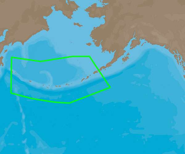
The NA-D962 coverage of Unimak Pass to Attu Island is included in the C-MAP 4D package.
Discover more exciting features and specifications of C-MAP 4D:
– Detailed coverage: The NA-D962 chart provides detailed coverage and accurate information for navigating through Unimak Pass to Attu Island.
– Advanced features: C-MAP 4D charts offer advanced features such as high-resolution bathymetry, 3D chart view, and satellite imagery. These features enhance your navigation experience and help you make informed decisions on the water.
– Updatable charts: With C-MAP 4D, you can keep your charts up to date by easily downloading the latest updates online. This ensures that you have the most accurate and reliable navigation information at all times.
– Compatible devices: The NA-D962 chart is compatible with Furuno 1670F / 1870F, and Standard CPN 7000i, and CPN1010i units. This compatibility makes it easy to integrate the C-MAP 4D charts into your existing navigation system.
– Additional data and services: C-MAP 4D allows you to add additional data and services to your charts as they become available. This gives you the flexibility to customize your boating experience and access the latest information relevant to your navigation needs.
– User-friendly interface: The C-MAP 4D charts feature a user-friendly interface that is easy to navigate. Whether you are a seasoned sailor or a beginner, you will find it intuitive to plan your routes and explore the water using the C-MAP 4D charts.
Frequently Asked Questions
Q: Can the C-MAP 4D charts be updated?
A: Yes, the C-MAP 4D charts can be easily updated by downloading the latest updates online. This ensures that you have the most up-to-date navigation information available.
Q: What advanced features does C-MAP 4D offer?
A: C-MAP 4D charts offer advanced features such as high-resolution bathymetry, 3D chart view, and satellite imagery. These features enhance your navigation experience and provide you with more information to make informed decisions on the water.
Q: Which devices are compatible with the NA-D962 chart?
A: The NA-D962 chart is compatible with Furuno 1670F / 1870F, and Standard CPN 7000i, and CPN1010i units. This makes it easy to integrate the C-MAP 4D charts into your existing navigation system.
Q: Can I add additional data and services to the C-MAP 4D charts?
A: Yes, C-MAP 4D allows you to add additional data and services to your charts as they become available. This gives you the flexibility to customize your boating experience and access the latest information relevant to your navigation needs.
Q: Is the C-MAP 4D interface user-friendly?
A: Yes, the C-MAP 4D charts feature a user-friendly interface that is easy to navigate. Whether you are a seasoned sailor or a beginner, you will find it intuitive to plan your routes and explore the water using the C-MAP 4D charts.



Saida –
Chelse –
Son –