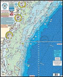
The Home Port Chart 3 offers mariners a comprehensive and detailed view of the coastal areas, valuable for navigation, fishing, and recreational boating. Representing a wide swath of the eastern seaboard, this chart is suitable for both professional mariners and pleasure cruisers looking for a reliable resource.
Here are some of the key features of the Home Port Chart 3:
- Locations:
- Montauk Point
- Shinnecock
- Fire Island
- Sandy hook
- Shark River Inlet
- Manasquan Inlet
- Barnegat Inlet
- Absecon Inlet
- Cape May Inlet
- Ocean City, MD Inlet
- Wachaprague
- Rudee Inlet
- Oregon Inlet
- Canyons:
- Chicken Canyon
- Hudson Canyon
- Toms
- Mey
- Hendrickson
- Lindenkohl
- Carterett
- Berkeley
- Spencer
- Wilmington
- Baltimore
- North Vries
- South Vries
- North Heyes
- South Heyes
- Poorman's
- South Poorman's Washington
- Norfolk Canyon
- Fishing Grounds:
- Mud Hole
- Monster Ledge
- Mako Hotel
- The Point
- No Name Shoal
- 42 Fathom Basin
- The Tongue
- The Flats
- Babylon Valley
- Emery Canyon
- Uchupl Canyon
- West Twin Dipper Canyon
- Letters South
- Letters North
- 1000 Fathom Tip
- Jones Valley
- Hudson Seamount
- Mey Canyon
- Hendrickson Canyon
- The Funnel
- Doc Strobel
- Toilet Seat
- Alligator Bight
- North Vries and South Vries Canyons
- Triple 0
- 461
- 471 Hump
- Rock Pile
- Lobster Pots
- Tarheel Mountain
- Northeast Grounds
- and many more.
- Laminated and waterproof for durability
- Color-coded depth and contour curve lines
- Latitude and longitude coordinates provided for every inlet
- Includes information on 84+ wrecks and reefs with gps coordinates
- Depths are measured in fathoms
This chart is especially useful for anglers targeting specific fishing grounds or divers seeking undersea wrecks and reefs. The inclusion of canyons is also essential for off-shore fishermen looking for deep-sea species.
The chart can be used in conjunction with other charts for those requiring comprehensive navigational data across different regions:
- #6 Mudhole Chart
- #7 Manasquan to Townsends Inlet Chart
- #10 Tuna Chart Bottom Structure Chart
- #12 GPS Canyons Chart
- #15 Tuna Chart Loan & GPS
- #34 Shrewsbury-Navesink-Metedeconk-Shark-Manasquan Rivers Chart
- #42 Raritan Bay and Ocean Chart
FAQs
1. Is this chart suitable for navigation in the mentioned areas?
Yes, the Home Port Chart 3 provides accurate information for navigation in the mentioned areas. It includes latitude and longitude coordinates for every inlet, making it easy to pinpoint locations.
2. Is the chart durable?
Yes, the chart is laminated and waterproof, ensuring its durability even in harsh marine conditions.
3. Are the depths on the chart in fathoms?
Yes, the depths on the chart are measured in fathoms, providing accurate information for fishing and boating purposes.
4. How many wrecks and reefs are included on the chart?
The chart includes information on 84+ wrecks and reefs, complete with GPS coordinates, making it a valuable resource for anglers and divers.
5. Can this chart be combined with other charts?
Yes, this chart can be combined with other compatible charts, providing comprehensive coverage of the desired areas for an even greater navigational experience.





Tarryn –
Erinn –
Nikia –
Garrick –