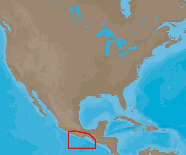
Features of C-MAP 4D Champerico, GT to Acapulco, MX – NA-D948
The C-MAP 4D NA-D948 is designed to provide boaters with a comprehensive set of features to improve their navigation and sailing experience. Some of the notable features of this advanced electronic marine chart include:
- High-resolution bathymetric data: Offering detailed contours and depth information that are crucial for fishermen and divers.
- Dynamic tides and currents data: Providing information about tidal heights, tidal streams, and predictions of time-specific water conditions.
- Photos and diagrams: Includes photos and diagrams of marinas and harbors for easier recognition and docking.
- High-resolution satellite imagery: Helps sailors to have a real-world perspective of coastal areas and unfamiliar landfalls.
- Easy Routing: Automatically plot the shortest, safest route based on detailed chart data and user vessel information.
- Compatible with multiple marine electronics: Designed to work with a specific range of chartplotters, ensuring seamless integration and functionality.
- Continual updates and upgrades: Option to add new data and services as they become available, keeping navigation information current.
- Customizable chart views: Modes for 3D overlay, satellite views, and traditional navigation charts.
- Marina port plans: Detailed layouts of ports and marinas to assist with berthing.
- Vector and raster chart presentation: Choose between different styles of chart presentations according to preference.
- Multilanguage capability: Making the navigation system more accessible to a wider range of users across different regions.
- Guardian Alarm: An optional feature that provides an extra level of safety, alerting the user if the vessel is nearing underwater obstructions.
Application and Use Cases
The C-MAP 4D NA-D948 marine chart is an essential tool for a wide array of maritime activities, including:
- Coastal Cruising: Navigators and cruisers can confidently plan trips from Champerico, GT to Acapulco, MX with the knowledge of the latest nautical information.
- Fishing: Anglers benefit from high-definition bathymetry to locate fish habitats and underwater structures.
- Diving: Divers use detailed depth information and site characteristics to discover and explore dive spots safely.
- Offshore Exploration: Mariners conducting offshore work rely on up-to-date information for safe route planning and situational awareness.
- Marine Traffic Management: Harbor masters and other authorities make use of the detailed harbors and marinas data for traffic control and docking assistance.
The C-MAP 4D Champerico, GT to Acapulco, MX – NA-D948 provides not only valuable navigational data but also enhances situational awareness and onboard safety, making it a vital asset for those navigating these waters.







Christine –
Lorenzo –
Madonna –
Jerred –
Bonnie –