The C-MAP 4D Electronic Marine Charts represent a quantum leap in navigation technology for boaters and seafarers. Tailored to serve a variety of boating requirements, these charts are not only advanced in their capabilities but also flexible, allowing for additional data and services to be incorporated as they emerge.
C-MAP 4D cartography is seamlessly integrated with a select range of navigation systems, namely the Furuno 1670F / 1870F, and Standard CPN 7000i, and CPN1010i units. This cross-compatibility ensures that users can benefit from C-MAP 4D's extensive features across multiple devices, enhancing the level of convenience for mariners.
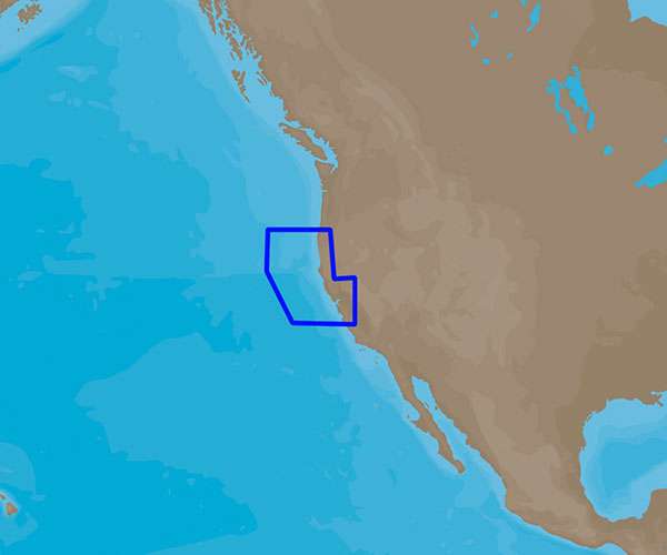
Specifically, the C-MAP 4D NA-D953 chart caters to voyagers navigating the waters from Point Sur to Cape Blanco. This chart provides intricate and precise marine mapping of the region, which is critical for safe and efficient navigation.
C-MAP 4D charts are packed with a suite of features and tech specs that altogether aim to amplify your time out on the water. These charts are a testament to modern navigation, offering the latest, most detailed, and reliable information to guide you through your maritime journeys.
Main Features of C-MAP 4D
- Detailed marine and coastal mapping coverage from Point Sur to Cape Blanco
- Compatibility with popular chart plotters such as Furuno 1670F / 1870F, Standard CPN 7000i, and CPN1010i units
- High-resolution bathymetric data for fishing and underwater exploration
- Dynamic tides and currents data to plan safe passages
- Port and marina information for docking and services planning
- Easy routing with suggested routes based on chart data and navigational aids
- Regular chart updates to ensure the most current information is available
- Ability to add custom layers and views for a personalized navigation experience
Frequently Asked Questions
Q: Can I use C-MAP 4D with different marine navigation systems?
A: Yes, C-MAP 4D cartography is designed to be versatile and compatible with a range of navigation systems including the Furuno 1670F / 1870F, and Standard CPN 7000i, and CPN1010i units.
Q: What is the coverage area of C-MAP 4D NA-D953?
A: The coverage area of the C-MAP 4D NA-D953 chart spans the marine expanse from Point Sur to Cape Blanco, providing comprehensive navigational details for the region.
Q: What features can I expect from C-MAP 4D?
A: C-MAP 4D is enriched with an array of features intended to improve your boating and navigation experience. Detailed cartography, dynamic content, and regular updates are some of the many functionalities that users can anticipate.




Camie –
Raina –
Rachel –
Liesl –