

C-MAP 4D Electronic Marine Charts represent the pinnacle of navigational charts for recreational and professional mariners alike. They are dynamic and user-friendly, offering a comprehensive maritime navigation solution that evolves with the latest data and updates. If you're keen on making your sea journeys safer and more efficient, C-MAP 4D is a choice to consider.
With its cutting-edge technology, the C-MAP 4D cartography transforms your compatible chartplotter into an essential tool to assist with planning and on-water activities. When you opt for the NA-D944 chart, you are not only equipping your vessel with a premium navigation aid but also laying the foundation for a seamless upgrade path as new data and functionalities become available.
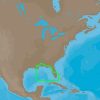
The specific NA-D944 chart offers expansive coverage, ranging from the serene waters of St. Lucie Inlet all the way to the bustling port city of New Orleans. This broad navigational area is well-suited for sailors and fishermen looking to traverse these diverse coastal regions.
Compatibility is key when it comes to maximizing your navigation system's performance. The C-MAP 4D charts are designed to work harmoniously with a selection of top chartplotter units, including the Furuno 1670F / 1870F, as well as the Standard CPN 7000i and CPN1010i models. Boaters who have these systems on board will find the integration of the C-MAP 4D seamless and user-friendly.
Dive Deeper into Navigation with the C-MAP 4D Features
What sets the C-MAP 4D NA-D944 apart are the progressive features and specifications that ensure navigational excellence. Among the myriad benefits you can expect detailed marine and land content, dynamic tidal and current predictions, high-resolution bathymetric data, and more.
Understanding the ins and outs of your charting system is crucial for safe navigation. Here are some of the common inquiries about the C-MAP 4D charts:
Frequently Asked Questions
What are the compatible units for the C-MAP 4D cartography?
The C-MAP 4D cartography is compatible with a range of units, specifically the Furuno 1670F / 1870F, and the Standard Horizon CPN 7000i and CPN1010i models.
What coverage does the NA-D944 chart provide?
The NA-D944 chart offers extensive coverage for coastal navigation from St. Lucie Inlet, Florida to New Orleans, Louisiana, enabling a vast range of passages and excursions.
What are the unique features and specifications of the NA-D944 chart?
The NA-D944 chart is enriched with multiple features and specifications designed to optimize your boating experience, such as 3D views, satellite images, and enriched port databases, ensuring you have all the necessary tools for a secured and informed voyage.
In summary, whether you're a seasoned captain or a recreational boater, the C-MAP 4D NA-D944 chart is a valuable addition to your navigational arsenal. Invest in a chart that progresses with technology and offers reliable and extensive navigational data to ensure a safe and enjoyable journey on the waters.


Keonna –
Stevenson –
Venessa –
Louie –
Rachel –