

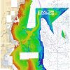
The Gulf of Maine CMOR Card is an exceptional product for mariners and boating aficionados looking to navigate the scenic and biologically rich waters of the Gulf of Maine using their Raymarine navigation systems. This product offers an expansive coverage area of 3,800 square miles delivering meticulous topographical details suitable for a variety of oceanic activities such as fishing, diving, and research operations.
The intricate details of the seafloor presented in this mapping product are underpinned by CMOR Mapping's high-resolution bathymetric data, which reveals a clearer picture of underwater structures and habitats. The Gulf of Maine CMOR Card gives users an edge with bathymetric data far more refined than standard chart offerings.
Enhancing its utility, the base layer of the card incorporates official NOAA Charts 13260, 13267, 13278, and 13286. This integration provides essential navigational information, thereby coupling the card's advanced bathymetry with crucial reference points and navigation aids.
Compatibility with Raymarine chartplotters is wide-ranging, requiring the units to support Lighthouse II or Lighthouse 3 operating systems—systems renowned for their ease of use and advanced capabilities. The Gulf of Maine CMOR Card is ready for use with the following list of devices:
- Axiom Series
- Axiom Pro
- Hybrid Touch
- aSeries
- cSeries
- eSeries
- eS Series
- gS Series
- Dragonfly Series
Frequently Asked Questions
Q: What is the coverage area of the Gulf of Maine CMOR Card?
A: The Gulf of Maine CMOR Card covers an area spanning 3,800 square miles, from the northern tip of Cape Cod, Massachusetts to Cape Elizabeth, Maine.
Q: How does the CMOR Mapping bathymetry provide superior data?
A: The CMOR Mapping bathymetry utilizes advanced technology to capture detailed and accurate seabed contours, which allows for more informed navigation and fish habitat identification, offering an advantage compared to traditional charting methods.
Q: What additional navigational information does the card provide?
A: Beyond detailed bathymetric contours, the card includes essential NOAA Charts 13260, 13267, 13278, and 13286 for comprehensive navigational information, seamlessly blending bathymetry with established marine cartography.
Q: Which Raymarine devices are compatible with the CMOR Mapping Gulf of Maine Card?
A: The card is broadly compatible with many Raymarine electronic chart systems. Specifically, it can be used with devices operating on the Lighthouse II or Lighthouse 3 interface, including various series such as Axiom, Axiom Pro, and Dragonfly, among others.


Obrian –
Garth –
Leroy –