

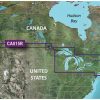
The BlueChart g3 HD – HXCA600X – Canada – microSD/SDC is a comprehensive chart that covers the North American coastline, from Newfoundland to Aberdeen, Washington. It includes areas such as the Ile d'Anticosti, New York Harbor, the Great Lakes of the US and Canada, British Columbia, Vancouver, the Queen Charlotte Islands, and Puget Sound. To create the charts, Garmin and Navionics data are integrated, ensuring an accurate representation of the areas.
Auto Guidance1 technology offers additional functionality, as it proposes a suitable path based on the desired depth and overhead clearance. This feature is useful for navigation planning, although it does not replace safe operational practices. The NOAA raster cartography is another free feature that provides chartplotter paper chart-like images for regions that NOAA has surveyed. This feature is available for downloading through the ActiveCaptain app, and the raster cartography is not available on the echoMAP CHIRP and ECHOMAP Plus combinations.
Shallow water shading, detailed contours, and up to 1′ contours are provided for efficient navigation, while companion cards or per-area downloads offer worldwide coverage. The ActiveCaptain mobile app allows mobile devices to access raster cartography. However, users are advised to note that this product contains chemicals known to the state of California to cause cancer, birth defects, and other reproductive damage. For further details, check P65Warnings.ca.gov.
Frequently Asked Questions
1. Can I use this BlueChart g3 HD in areas outside of Canada?
Yes, companion cards or per-area downloads are available for worldwide coverage.
2. How does the Auto Guidance1 technology work?
The Auto Guidance1 technology proposes a suitable path based on the desired depth and overhead clearance. It is useful for navigation planning, but it does not replace safe operational practices.
3. Is the NOAA raster cartography feature available on all Garmin devices?
No, the NOAA raster cartography is not available on the echoMAP CHIRP and ECHOMAP Plus combinations. It can be downloaded through the ActiveCaptain app.
4. What does the ActiveCaptain mobile app allow me to do?
The ActiveCaptain mobile app allows mobile devices to access raster cartography and provides additional features and functionalities.
5. Are there any warnings or precautions I should be aware of?
Yes, users are advised to note that this product contains chemicals known to the state of California to cause cancer, birth defects, and other reproductive damage. For further details, check P65Warnings.ca.gov.


Tanna –
Freda –
Camilla –
Katee –
Susannah –