Frequently Asked Questions
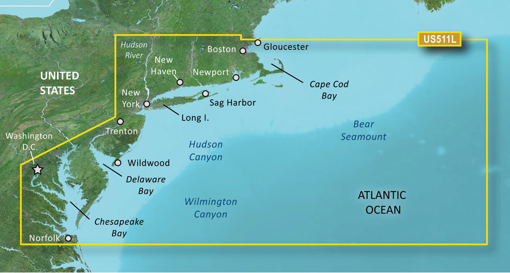
The Garmin VUS511L BlueChart g3 Vision HD – Boston to Norfolk – microSD/SD navigation system is a sophisticated and helpful navigational tool designed for boaters and fishermen. It provides detailed marine cartography that could be invaluable for safe and efficient navigation in coastal waters.
Q: What is included in the BlueChart g3 Vision HD – VUS511L – Boston – Norfolk – microSD/SD navigation system?
A: The BlueChart g3 Vision HD – VUS511L – Boston – Norfolk – microSD/SDC navigation system includes detailed marine cartography for a wide area including Cape Cod, Martha's Vineyard, and Nantucket Island. Furthermore, it provides bathymetric coverage of significant offshore features such as Georges Bank, the Bear Seamount, and the Hudson and Wilmington Canyons from Georges Basin to Baltimore Canyon, which are crucial for offshore navigation and fishing.
Q: What updates have been made to the BlueChart g3 Vision HD coastal charts?
A: The updates made to the BlueChart g3 Vision HD coastal charts include enhanced integration with both Garmin and Navionics data. The result is the provision of the most comprehensive, accurate, and up-to-date maritime cartography available to mariners, which incorporates both clarity and intricate detail for navigating coastal waters.
Q: What features does the BlueChart g3 Vision HD navigation system offer?
The BlueChart g3 Vision HD navigation system is packed with essential features to improve maritime navigation. Here are some key features:
- Auto Guidance technology: Suggests the best paths to follow for navigation.
- High-resolution Relief Shading: Offers a clearer view of the sea floor for improved fish finding and underwater terrain understanding.
- Depth Range Shading: Allows mariners to designate up to 10 different depth ranges, enabling a quick and easy way to view target depths.
- Shallow Water Shading: Highlights shallow water areas to avoid for safer navigation.
- High-resolution Satellite Imagery: Delivers a realistic view of the surroundings for better situational awareness.
Q: Can the BlueChart g3 Vision HD be used as a replacement for safe navigation operations?
A: While the advanced features of the BlueChart g3 Vision HD are highly beneficial, they are not a substitute for safe navigation practices. Mariners should continue to rely on officially published charts, maintain local knowledge of waters, and utilize a variety of navigational aids to ensure safety at sea.
Q: Are there any warnings or precautions for using the BlueChart g3 Vision HD navigation system?
A: As with any electronic product, users should be aware of potential chemical exposures. For residents of California, specific attention should be paid to the warning that this product may contain chemicals known to the state to cause cancer, birth defects, or other reproductive harm. Further details can be found by visiting P65Warnings.ca.gov.
The Garmin VUS511L BlueChart g3 Vision HD – Boston to Norfolk is an advanced navigational tool that not only enhances the experience of exploring coastal waters but also promotes safer navigation practices through its multitude of features. When employed alongside other navigational aids and updated maritime knowledge, it can serve as a powerful asset for any mariner's journey.





Melodie –
Douglas –
Paxton –
Rylan –
Tyran –
Savana –
Lani –
Nathon –
Lucius –
Sanjuanita –
Arlo –
Lesa –