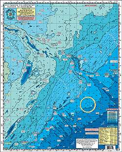
Discover the amazing underwater structures in this chart!
This chart provides you with the distances from each inlet to the Canyons. Explore the 30 Fathom Curve that extends east past 1000 Fathoms. It showcases a number of notable locations such as The Glory Hole, Hudson, Tom's, Berkely, Carteret, Lindenkohl, Spencer, Wilmington, Baltimore, Poormans, and the South Poormans Canyons, as well as the 500 Fathom Lumps outside Washington Canyon. The chart is laminated and waterproof, making it durable for any fishing adventure.
The chart features color-coded depth and contour curve lines, allowing for easy interpretation of the underwater topography. Peaks and canyons are clearly indicated with gps LAT/LON coordinates. You'll also find various fishing grounds highlighted on the chart, including The Glory Hole, No Name Shoal, 42 Fathom Basin, The Point, The Flats, The Tongue, 200/100, The Bombs, Chicken Canyon, Jones Valley, Babylon Valley, The Letters, The Rabbit Ears, The Funnel, The Lobster Claw, The Elephant Trunk, The 500 Square, The West Notch, The 500 Fathom Lumps, and many more.
Additionally, wrecks are marked with GPS LAT/LON coordinates for your convenience. Some of the wreck sites featured on the chart include Bacardi, Texas Tower, Olinda, Bidevind, Lexington, West Wreck, Larson, Huntington, Herb Parker, Haskell, U-869 Sub, Isabel Wiley, EH Cole, Carolina, Texel, Winneconne, USS Murphy, Rio Tercero, Sea Skip, Miss Arlene, India Arrow, and many more.
Please note that the depths on this chart are measured in Fathoms. This chart is a great addition to your fishing arsenal and complements other charts in the series. It connects seamlessly with Chart #6 “Mud Hole” Chart from Sandy hook to Ocean City NJ, as well as Chart #10 “Tuna Chart” from Barnegat to Ocean City MD.
Frequently Asked Questions
1. What are the notable locations featured on this chart?
The notable locations featured on this chart include The Glory Hole, Hudson, Tom's, Berkely, Carteret, Lindenkohl, Spencer, Wilmington, Baltimore, Poormans, and the South Poormans Canyons, as well as the 500 Fathom Lumps outside Washington Canyon.
2. Are fishing grounds highlighted on the chart?
Yes, various fishing grounds are highlighted on the chart, including The Glory Hole, No Name Shoal, 42 Fathom Basin, The Point, The Flats, The Tongue, 200/100, The Bombs, Chicken Canyon, Jones Valley, Babylon Valley, The Letters, The Rabbit Ears, The Funnel, The Lobster Claw, The Elephant Trunk, The 500 Square, The West Notch, The 500 Fathom Lumps, and many more.
3. Are wrecks marked on the chart?
Yes, wrecks are marked on the chart for your convenience. Some of the wreck sites featured include Bacardi, Texas Tower, Olinda, Bidevind, Lexington, West Wreck, Larson, Huntington, Herb Parker, Haskell, U-869 Sub, Isabel Wiley, EH Cole, Carolina, Texel, Winneconne, USS Murphy, Rio Tercero, Sea Skip, Miss Arlene, India Arrow, and many more.
4. What units are used to measure the depths on this chart?
The depths on this chart are measured in Fathoms.
5. Does this chart complement other charts in the series?
Yes, this chart is a great addition to your fishing arsenal and complements other charts in the series. It connects seamlessly with Chart #6 “Mud Hole” Chart from Sandy Hook to Ocean City NJ, as well as Chart #10 “Tuna Chart” from Barnegat to Ocean City MD.




Kaitlynn –
Sara –
Jacque –
Mallery –
Tino –
Antonino –
Gianna –
Brittainy –