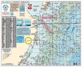
The Easy-to-Read Home Port Chart 15 is a comprehensive nautical map designed for serious fishermen and boaters who navigate the waters known for the rich fishing grounds it covers. Specifically tailored for the offshore fishing community, this chart is crucial for those targeting Tuna and other prized species, and is notable for including the phrase “TUNA GROUNDS” prominently. All depth measurements are provided in fathoms, making it suitable for deep-sea fishing and exploration. The chart incorporates both gps and LORAN coordinates, confirming its versatility for different navigation systems and preferences.
Fishing Grounds Featured:
- Sea Isle Ridge
- Five Fathom Bank
- NE Lump
Wrecks Shown:
- Varanger
- Bass Barn
- Champion
Chart Features:
- Laminated and waterproof, ideal for the challenging marine environment
- Color-coded depth and contour curve lines for easy and quick readability
- Detailed bottom structure representation, including holes, shoals, humps, and peaks
- Comprehensive list of wrecks with coordinates shown in both GPS and Loran, catering to different users
Joins Charts:
This chart is part of a more extensive nautical mapping system that can be connected with other charts for expanded coverage:
- #1 Delaware Bay
- #2 Beach Haven to Cape May, NJ to Fenwick Island, DE
- #3 All Canyons Hudson to Norfolk
- #10 Tuna Chart – Barnegat to Cape May, NJ to O.C, MD
- #12 Canyons – Hudson to S. Poorman's
Frequently Asked Questions
1. Is this chart laminated and waterproof?
Yes, this chart is laminated and waterproof, making it durable and ideal for use on the water.
2. Are the depths and contour lines color-coded?
Yes, the depths and contour curve lines on this chart are color-coded, which enhances readability and simplifies the navigation process.
3. Does the chart show detailed bottom structures?
Indeed, the chart meticulously displays detailed bottom structures, encompassing holes, shoals, humps, and peaks, that are instrumental for anglers and divers.
4. Can I find wrecks listed on this chart using GPS or Loran?
Absolutely, wrecks and other notable features are cataloged with precision, available through both GPS and Loran coordinates, supporting various navigation technologies.
5. Which other charts does this chart join?
This chart joins a suite of other charts, forming a network that provides comprehensive and detailed coverage for recreational and professional fishing, maritime navigation, and ocean exploration.
The Easy-to-Read Home Port Chart 15 is an essential tool for mariners seeking a reliable and informative resource, capturing the intricacies of the underwater landscape that is as valuable to the offshore fisherman as it is to the adventurous explorer of the high seas.



Ronda –
Feliciano –