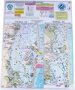
Home Port Chart 22 is an invaluable tool for maritime enthusiasts, particularly kayakers. It features in-depth coverage of the area from Manasquan Inlet to Metedeconk River, with a special emphasis on Bay Head Harbor. Additionally, it includes the Intracoastal Waterway (ICW), showcasing key locations such as Mantoloking, Kettle Creek, Silver Bay, Tom's River, and Cedar Creek, stretching all the way to Tices Shoal. As it progresses, it details Forked River, Oyster Creek Channel, Double Creek Channel, and Manahawkin Bay, culminating at Little Egg Harbor. It even denotes an unmarked channel just north of Myers Hole, which provides a passage between Barnegat Inlet to Double Creek Channel.
This navigational aid goes beyond mapping to offer several features crucial for safe and informed boating:
- Clearly marked buoys, daymarkers, and lighted markers for easy navigation.
- Identification of recommended fish species and their natural habitats for fishing enthusiasts.
- Depiction of Holes and Peaks, which are vital for understanding the underwater terrain.
- Illustration of bridges with their respective vertical clearances, ensuring safe passage for various vessels.
- Locations of marinas and boat ramps for convenient access and docking.
- Waterproof depth and contour curve lines that are both color-coded and laminated for durability and clarity.
- Designation of prominent areas known for crabbing activities.
Furthermore, Home Port Chart 22 is designed to complement and integrate with a series of other charts, providing extensive coverage for navigators. These charts include:
- Chart #6: Mud Hole Chart – Sandy Hook to Ocean City, NJ
- Chart #7: Manasquan to Great Egg Inlet, extending out 20 miles
- Chart #10: Tuna Chart – Barnegat to Ocean City, MD
- Chart #11: ICW Barnegat-Beach Haven-Atlantic City-Ocean City & Mullica River
- Chart #16: Inshore Shark River-Manasquan-Barnegat Inlets
FAQs
1. Can this chart be used by boaters other than kayakers?
Yes, Home Port Chart 22 can be utilized by any boater navigating the aforementioned areas, not just kayakers, offering a broad range of details essential for safe boating.
2. Are the bridges' vertical clearances accurately marked on the chart?
Yes, the bridges within the charted region are illustrated with accurate vertical clearances, aiding in route planning.
3. Is the chart waterproof?
Indeed, the depth and contour lines are color-coded and laminated, ensuring the chart remains useful and intact in wet conditions.
4. Are there any specific areas highlighted for crabbing?
Yes, the chart pinpoints specific areas known for crabbing, making it a beneficial guide for those seeking to engage in this activity.





Christain –
Nakeshia –
Bretton –
Antione –
Lamonica –