

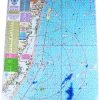
This chart is designed for use near the shore, up to 15 miles out. It provides important information for boaters and anglers.
Artificial Reefs
The chart shows the locations of several artificial reefs, including Sea Girt, Shark River, Axel Carlson, Barnegat Light Reef, Garden State North, Garden State South, Little Egg, Great Egg Reef, Atlantic City Reef, and Townsends Inlet Reef.
Navigation Lines
A 3 nautical mile line is displayed on the chart, as well as 5 mile radius lines from each inlet. These lines help boaters navigate effectively.
Laminated and Waterproof
The chart is laminated and waterproof, ensuring durability and protection from water damage.
Bottom Structure
Clear indications of bottom structure are shown on the chart, including holes, peaks, shoals, and color-coded depth and contour curve lines.
fishing Grounds
The chart identifies various fishing grounds, such as Klondike Bank, Humpty Dumpty, Little Italy, Manasquan Ridge, “EN” Rocks, Tolton Lump, ESS Ledge, Oley's Lump, North Barnegat Ridge, West Hole, South Barnegat Ridge, Harvey Cedars Lump, Atomic Lump, Brigantine Shoal, Lobster Hole, Cuma Lumps, Coral Bottom, Stone Beds, Table Top, Sea Isle Lump, Dog Lump, Hambone, Triple Lumps, and AC Lobster Pots.
Wrecks
The chart provides DGPS (Differential Global Positioning System) coordinates for various wrecks, including Blue Dog II, Blue Dog I, Mildred, Cadette, Mahogany, Logwood, Sea Girt Wreck, Dave Moran, Mohawk, Coffee, Shopping Cart, Queen, Lana Carol, Sovereign, Duncan, Emerald City, Anastasia, Tolton, Truro, Maurice Tracy, Gov Mansion, Hankins, Gulf Trade (stern), Vixen, Hargraves, Spanish, Hammies, Gulf Trade (bow), Chesapeake, Reliance, San Saba, Great Isaac, YO 153, Brick Wreck, Magnus, Summer, Good Ship Lollipop, Crystal Gayle, Russell, Wellington, S. Cotles, Glory Wreck, Hornet, Moran, Almirante, Astra, SE Wreck, Pet Wreck, Old Mud Digger, Florida, Oil Wreck, Clam Boat, Swanaka, San Jose, Blackie, $25 Wreck, The Libra, Salem, Bay Jack, Martino, and many more.
Chart Connections
This Home Port Chart 7 connects with the following charts:
- #6 Mud Hole Chart
- #16 Inshore Shark River – Manasquan – Barnegat Inlets
- #11 ICW Barnegat south to Great Egg Inlet with the Mullica River
- #34 Shrewsbury – Navesink – Metedeconk – Shark – and Manasquan Rivers
- #22 ICW Manasquan Inlet – Barnegat Bay – Manahawkin Bay
Frequently Asked Questions
What is the range of this chart?
This chart is designed for use near the shore, up to 15 miles out.
What information does the chart provide?
The chart provides information on artificial reefs, navigation lines, bottom structure, fishing grounds, wrecks, and chart connections.
What are the artificial reefs shown on the chart?
The artificial reefs shown on the chart include Sea Girt, Shark River, Axel Carlson, Barnegat Light Reef, Garden State North, Garden State South, Little Egg, Great Egg Reef, Atlantic City Reef, and Townsends Inlet Reef.
What are the navigation lines on the chart for?
The chart displays a 3 nautical mile line, as well as 5 mile radius lines from each inlet, to help boaters navigate effectively.
Is the chart laminated and waterproof?
Yes, the chart is laminated and waterproof, ensuring durability and protection from water damage.
What bottom structures are indicated on the chart?
The chart shows clear indications of bottom structure, including holes, peaks, shoals, and color-coded depth and contour curve lines.
What fishing grounds are identified on the chart?
The chart identifies various fishing grounds such as Klondike Bank, Humpty Dumpty, Little Italy, Manasquan Ridge, “EN” Rocks, Tolton Lump, ESS Ledge, Oley's Lump, North Barnegat Ridge, West Hole, South Barnegat Ridge, Harvey Cedars Lump, Atomic Lump, Brigantine Shoal, Lobster Hole, Cuma Lumps, Coral Bottom, Stone Beds, Table Top, Sea Isle Lump, Dog Lump, Hambone, Triple Lumps, and AC Lobster Pots.
What wrecks are included on the chart?
The chart provides DGPS coordinates for various wrecks including Blue Dog II, Blue Dog I, Mildred, Cadette, Mahogany, Logwood, Sea Girt Wreck, Dave Moran, Mohawk, Coffee, Shopping Cart, Queen, Lana Carol, Sovereign, Duncan, Emerald City, Anastasia, Tolton, Truro, Maurice Tracy, Gov Mansion, Hankins, Gulf Trade (stern), Vixen, Hargraves, Spanish, Hammies, Gulf Trade (bow), Chesapeake, Reliance, San Saba, Great Isaac, YO 153, Brick Wreck, Magnus, Summer, Good Ship Lollipop, Crystal Gayle, Russell, Wellington, S. Cotles, Glory Wreck, Hornet, Moran, Almirante, Astra, SE Wreck, Pet Wreck, Old Mud Digger, Florida, Oil Wreck, Clam Boat, Swanaka, San Jose, Blackie, $25 Wreck, The Libra, Salem, Bay Jack, Martino, and many more.
Which charts does Home Port Chart 7 connect with?
This Home Port Chart 7 connects with Mud Hole Chart, Inshore Shark River – Manasquan – Barnegat Inlets, ICW Barnegat south to Great Egg Inlet with the Mullica River, Shrewsbury – Navesink – Metedeconk – Shark – and Manasquan Rivers, and ICW Manasquan Inlet – Barnegat Bay – Manahawkin Bay.


Crystel –
Mykel –
Aubrie –
Darren –