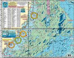
The Home Port Chart 10 is an indispensable tool for fishing enthusiasts and mariners requiring comprehensive details about bottom structures that are crucial for successful fishing ventures. It provides an intricate look at the ocean floor, helping users to locate holes, shoals, lumps, and bumps along various coastal inlets that are known for diverse marine life and popular fishing spots.
The coverage provided by the chart is extensive. It includes critical navigation regions such as Barnegat Inlet, Little Egg Inlet, Absecon Inlet, Great Egg Inlet, Cape May Inlet, Indian River DE Inlet, and Ocean City MD inlet. The chart is bolstered by 10-mile radius lines from each inlet and reaches out to 50 miles offshore, ensuring a vast area for explorers to utilize.
To ensure usability in all conditions, the chart is both laminated and waterproof. This makes it an ideal companion for any trip out on the water, regardless of weather conditions. Its durability is a valuable feature, lending peace of mind to users who rely on the chart for safety and guidance.
Aside from navigational features, the chart includes valuable information regarding an impressive number of 89+ wrecks and reefs in the area, each with its own story and potential as a thriving fish habitat. Some of the most notable sites on the chart include:
- Anastasia
- Cow Wreck
In addition, the chart provides DGPS LAT/LON coordinates for various renowned fishing grounds, affording anglers with precise locations to plan their outings. These include but are not limited to:
- The Slough
- The Ledges
Another beneficial feature of this chart is its ability to be used in conjunction with other charts in the series. This interconnected system allows users to expand their knowledge and navigational capabilities in adjacent waters. Charts that are compatible with Home Port Chart 10 include:
- #1 Delaware Bay
- #2 Inshore Beach Haven to Cape May to Indian River DE
FAQs
What is the main purpose of this chart?
The main purpose of the Home Port Chart 10 is to aid in offshore navigation by providing detailed topographic information on bottom structures that are vital for anglers and mariners.
Which inlets are covered by Home Port Chart 10?
Home Port Chart 10 covers a number of key inlets including Barnegat Inlet, Little Egg Inlet, and others that are essential to the East Coast fishing community.
What is the extent of the coverage provided by the chart?
The chart provides nautical guidance extending out to a 50-mile radius from the listed inlets, including 10-mile radius landmarks for detailed local fishing and navigation.
Is the chart durable?
Yes, it is designed to be durable, with lamination and water-resistant features making it suitable for regular use in the harsh marine environment.
Does the chart provide information about wrecks and reefs?
Indeed, it details over 89 wrecks and reefs, which are hotspots for marine life and attract a wealth of fishing activity.
Can the chart be used in conjunction with other charts in the series?
Yes, Home Port Chart 10 can be combined with other charts in the series for broader navigation and more in-depth exploration of the East Coast waters.





January –
Aris –
Elbert –
Samson –