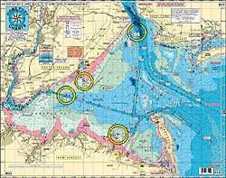
Recent updates have been made to the Ambrose Channel and Ocean Front, with particular attention to the New York – New Jersey state line. Specifically designed to detail fishing grounds, channels, and buoys, Home Port Chart 42 serves as an essential tool for navigating Raritan Bay. It features precise on-site gps coordinates for each location and showcases the unique bottom structure of the Atlantic Ocean fishing grounds, inclusive of the Mud Hole extending up to 20 miles offshore.
The fishing grounds on the Raritan Bay side are abundant and include many popular spots, making them ideal for activities like kayaking. Here are some of the featured areas:
- Gong Grounds
- Tin Can Grounds
- 14 ft Channel
- Point Comfort Shoal
- Great Bed Reach
- Spermaceti Cove
The ocean side of the chart highlights more fishing grounds, known for their abundance and variety:
- Scallop Ridge
- Clam Beds
- Shark Ledge
- “EN” Rocks
For wreck and reef fishing enthusiasts, Home Port Chart 42 incorporates a list of artificial reefs and wreck sites, complete with DGPS coordinates:
- Sandy hook Reef
- Sea Girt Reef
- Axel Carlson Reef
- Mohawk
- Bald Eagle
- Arundo II
Practical features of this chart that enhance its utility include:
- Laminated and waterproof material
- Color-coded depth and contour lines
- Labeled lighted and unlighted buoys and range markers with LAT/LON coordinates
- Designations of boat ramps
- Depth measurements provided in feet
Apart from being a standalone navigational asset, this chart is part of a series designed for comprehensive seafaring needs. It is complementary to other charts such as #3 All Canyons Hudson to Norfolk, #6 Mud Hole Chart Sandy Hook to Ocean City MD, and others within the coverage from Manasquan Inlet to Manahawkin Bay.
Frequently Asked Questions
1. Can I use this chart for kayaking?
Yes, Home Port Chart 42 highlights many great kayaking spots within the Raritan Bay.
2. Does the chart cover fishing grounds in the Atlantic Ocean?
Indeed, it features extensive bottom structure details and fish-holding spots like the Mud Hole up to 20 miles from shore.
3. Are there any artificial reefs mentioned on the chart?
Yes, it includes well-known reefs such as Sandy Hook Reef, Sea Girt Reef, and Axel Carlson Reef.
4. Are the GPS coordinates provided for wrecks and buoys?
Certainly, the chart offers accurate GPS coordinates for various wrecks and buoy markers.
5. Is the chart laminated and waterproof?
Yes, this feature makes the chart both durable and suitable for use in wet conditions.






Leila –
Kaisha –
Charlton –
Apollonia –
Ladarius –
Young –
Denielle –