

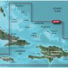
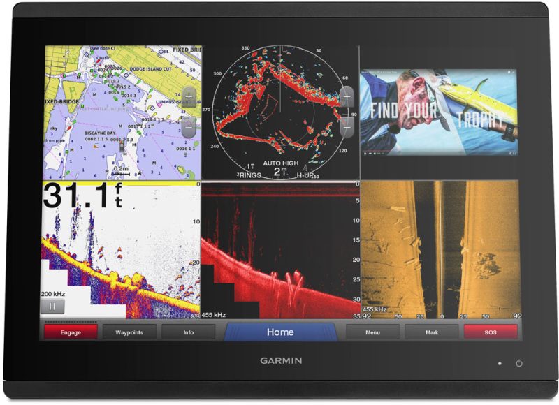
The Garmin HXUS029R BlueChart g3 HD – Southern Bahamas is a comprehensive coastal chart that covers the Bahamas, including Great Exuma, Great Inagua, Mayaguana, Jamaican, Haitian, and Dominican coasts, as well as the easternmost quarter of Cuba and the Turks and Caicos Islands. It features up-to-date data from Explorer Charts, as well as integrated Garmin and Navionics data, providing industry-leading coverage, clarity, and detail.
One of the key features of this chart is the Auto Guidance technology. Using your desired depth and overhead clearance, it calculates the most suitable route and provides a suggested path to follow. This is particularly useful for navigation purposes.
The BlueChart g3 HD – Southern Bahamas also includes detailed contours, shallow water shading, and NOAA raster cartography. The contours provide accurate bottom structure depiction, making it a valuable tool for fishing charts and navigation in swamps, canals, and marinas. The shallow water shading helps to identify shallow areas that may pose a navigational challenge.
For those who prefer a paper chart-like view, NOAA raster cartography is available as a free downloadable feature through the ActiveCaptain app. This enables users to have a traditional chartplotter view of areas that have been surveyed by NOAA.
It's important to note that the Auto Guidance feature is for planning purposes only and should not be relied upon as a replacement for safe navigation operations. It's always essential to practice safe navigation techniques when on the water.
Please be aware that this product contains chemicals known to the State of California to cause cancer, birth defects, or reproductive harm. For more information, please visit P65Warnings.ca.gov.
Frequently Asked Questions
Q: Can I use this chart for navigation in the Bahamas?
A: Yes, the Garmin HXUS029R BlueChart g3 HD – Southern Bahamas is specifically designed for navigation in the Bahamas, providing comprehensive coverage of the region.
Q: How does the Auto Guidance feature work?
A: The Auto Guidance feature uses user-defined parameters such as desired depth and overhead clearance to calculate the most suitable route and provide a suggested path to follow. It helps with navigation planning and can be a valuable tool for safe and efficient boating.
Q: What is the benefit of the detailed contours in this chart?
A: The detailed contours in the BlueChart g3 HD – Southern Bahamas provide accurate bottom structure depiction, making it an invaluable tool for fishing charts and navigation in swamps, canals, and marinas.
Q: Can I have a paper chart-like view with this product?
A: Yes, you can have a paper chart-like view with the BlueChart g3 HD – Southern Bahamas by downloading the NOAA raster cartography feature through the ActiveCaptain app. This allows you to have a traditional chartplotter view of areas that have been surveyed by NOAA.
Q: Is the Auto Guidance feature a replacement for safe navigation techniques?
A: No, the Auto Guidance feature is for planning purposes only and should not be relied upon as a replacement for safe navigation operations. It is essential to always practice safe navigation techniques when on the water.


Chassidy –
Jacie –
Ryanne –
Jacki –