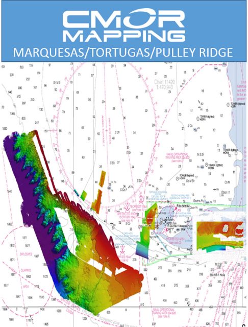
The CMOR mapping card for Raymarine is an invaluable resource for boaters and anglers looking to explore and fish in the waters around the Marquesas Keys, Dry Tortugas, Pulley Ridge, and the Florida Canyons. Specifically designed for use with Raymarine navigation systems, this card offers highly detailed bathymetric maps that contribute to a safer and more productive experience on the water.
Here is an expanded set of features of the CMOR mapping card:
- Detailed Coverage: The card includes comprehensive mapping of each area, with different depths represented for accurate underwater understanding.
- High-Resolution Imaging: The card delivers high-resolution images of bottom structure, which are essential for anglers looking to locate prime fishing spots.
- Insightful Data: Users gain access to data that includes depth changes, locations of coral heads, canyons, and other geological features beneficial for fishing or navigating.
- Regulation Awareness: The inclusion of background NOAA Charts 11439 and 11013 assists boaters in staying compliant with local maritime regulations, including restricted areas in the Tortugas.
- Compatibility: The card is compatible with a wide range of Raymarine units, supporting those with Lighthouse II and Lighthouse 3 interfaces and requiring a minimum of v17 software.
- Plug-and-Play Convenience: Provided on a Micro SD card along with a standard SD adapter, the CMOR card is easy to insert and start using right away.
Whether you are deep-sea fishing, diving, or navigating tricky areas, the comprehensive underwater detail on this mapping card is designed to enhance your maritime activities around the featured geographical areas.
Frequently Asked Questions
Is the CMOR mapping card compatible with other brands of marine devices?
No, the CMOR mapping card is specifically designed for compatibility with Raymarine systems only.
Do I need to update my Raymarine device software to use the CMOR mapping card?
Yes, a current software version is crucial; your device must be running either Lighthouse II or Lighthouse 3 with at least v17 software to ensure compatibility with the CMOR mapping card.
What areas are covered by the CMOR mapping card?
The card includes detailed maps for the Marquesas Keys, Dry Tortugas, Pulley Ridge, and the expansive Florida Canyons.
What depths are covered by the CMOR mapping card?
Coverage varies across regions, but overall it spans from shallow waters of 1′ to deep-sea areas reaching depths of 11,200′.
Does the CMOR mapping card include any additional features?
Yes, one of the key features is its detailed representation of bottom structures, which is pivotal for identifying fishing hotspots and aiding in safer navigation.
Are there any restrictions or regulations I need to be aware of when using the CMOR mapping card in the Tortugas?
Indeed, boaters should be aware of and comply with special regulations in the Tortugas, such as restrictions on anchoring, spearfishing, and entering protected areas. It is always advisable to review these regulations before planning activities in these waters.



Jereme –
Latashia –
Delorean –
Chiquita –
Pierce –