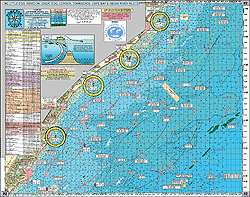
The Home Port Chart 2 offers an extensive and detailed look at the coastal regions from Little Egg Inlet in New Jersey to Indian River Inlet in Delaware, spanning over 20 miles. It's an essential tool for mariners, fishers, and maritime enthusiasts who seek a comprehensive guide to this scenic and activity-rich area of the Atlantic seaboard.
Mariners navigating the coast will appreciate the chart for its detailed representation of the seabed, showcasing an impressive array of underwater structures, including more than 186 wrecks and reefs. This meticulously crafted chart includes famous artificial reef sites such as Little Egg Reef, Atlantic City Reef, and others, providing insights into diverse ecosystems and promising spots for diving expeditions and fishing adventures.
Anglers will find the local fishing grounds and hot spots invaluable, as they highlight areas not typically found on standard nautical charts. The inclusion of local favorites such as Dog Lump and AC Lobster Pots signifies its utility in discovering hidden gems for the most experienced fishers. Such features are imperative for those targeting specific species or seeking the thrill of offshore fishing excursions.
Historians and wreck enthusiasts will be captivated by the wreck locations plotted on this chart, such as the notorious Crystal Gayle and Glory Wreck, shedding light on the maritime heritage embedded in the ocean floor. These sites are not only of interest for historical relevance but also serve as hotspots for marine life, making them popular among those interested in marine biology or underwater photography.
The chart's laminated and waterproof design ensures durability and longevity, a key consideration for any marine gear. Its color-coded depth and contour lines offer clarity and precision, while the 5-mile radius lines from each inlet are incredibly useful for distance estimation and navigation.
One of the standout aspects of the Home Port Chart 2 is its compatibility with adjoining charts. It can seamlessly integrate with other charts for expanded coverage of the region. This interconnectivity allows mariners to create a tailored navigation experience by overlapping with charts like the Tuna Chart Bottom Structure Chart and the ICW Atlantic City to Cape May chart.
FAQs
Q: What is the coverage area of this chart?
A: The chart covers a significant stretch of coastline, giving navigators and fishers a broad view of the area between Little Egg Inlet and Indian River Inlet, thus facilitating a range of maritime activities over this 20-mile span.
Q: What kind of underwater structures are displayed on this chart?
A: The chart is a treasure trove of underwater formations, with over 186 shipwrecks and reefs meticulously charted. The inclusion of popular and recently updated artificial reef sites offers a valuable resource for planning dives and fishing trips.
Q: Are there any specific fishing grounds or hot spots included on this chart?
A: Indeed, the chart is a boon to anglers with its detailed mapping of localized fishing grounds and less-known hot spots. This abundance of information can make all the difference in a successful offshore fishing venture.
Q: What wrecks and wreck locations are highlighted on this chart?
A: An extensive list of wrecks is documented, providing historical context and present-day exploration opportunities. These sites also often act as artificial habitats for marine wildlife, enriching the biodiversity of the region.
Q: What are the features of this chart?
A: The chart stands out for its rugged design and user-friendly features. The inclusion of color-coded depth markings and contour lines enhances readability, while the radius lines from inlets help with orientation and measuring distances.
Q: Can this chart be joined with other charts?
A: Yes, this chart offers the flexibility to join with a variety of other navigational charts to provide extended coverage and detailed information for an improved maritime navigation experience.
With its detailed structure, insightful points of interest, and robust design, the Home Port Chart 2 emerges as an indispensable tool for anyone involved in maritime activities along this vibrant stretch of the Atlantic coast.





Amira –
Alfonso –
Laronda –
Velvet –
Errol –
Megan –