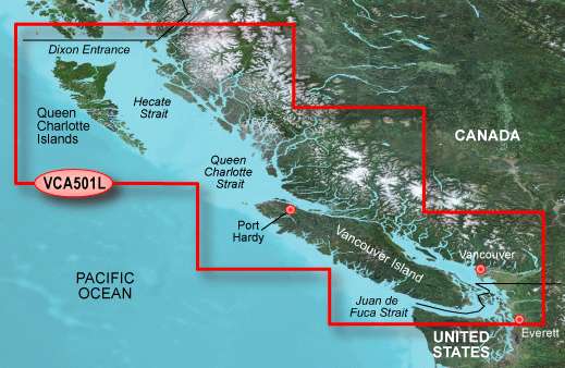
The Garmin BlueChart g2 Vision is a top-of-the-line marine charting device specifically designed for navigation in the coastal waters of British Columbia. It spans a vast area from the Strait of Juan de Fuca to the Dixon Entrance, providing comprehensive coverage of this region.
One of the standout features of the Garmin BlueChart g2 Vision is its ability to display high-resolution satellite photos. This allows boaters to have a detailed view of their surroundings, enhancing situational awareness and making navigation safer and more efficient.
The device also offers 3-D perspective, which means that charts can be viewed with a three-dimensional representation, giving users a better sense of the underwater terrain and enhancing their understanding of the area they are navigating.
Auto navigation technology is another noteworthy feature of the Garmin BlueChart g2 Vision. This means that the device can automatically calculate the best route for boaters, taking into consideration factors such as currents, tides, and obstacles. This feature can save time and effort for users, ensuring they stay on course and reach their destinations more easily.
In addition to the advanced charting capabilities, the Garmin BlueChart g2 Vision also provides users with access to aerial pictures and coastal road information. This can be particularly useful for boaters who want to explore the surrounding areas and find points of interest along the coast.
To unlock the full potential of the Garmin BlueChart g2 Vision, users can utilize a BlueChart g2 Vision SD card. This card integrates seamlessly with Garmin's GPSMAP 5XXX series, GPSMAP 4XXX series, GPSMAP 5X5 series, GPSMAP 5X0 series, and GPSMAP 4X0, allowing users to take advantage of all the device's features and functionalities.
Overall, the Garmin BlueChart g2 Vision is an impressive marine charting device that offers a wide range of advanced features to enhance the navigation experience in British Columbia's coastal waters. Its high-resolution satellite photos, 3-D perspective, auto navigation technology, aerial pictures, and coastal road information make it a valuable tool for boaters seeking accurate and detailed charting capabilities.
Frequently Asked Questions
What devices are compatible with the Garmin BlueChart g2 Vision SD card?
The Garmin BlueChart g2 Vision SD card is compatible with Garmin's GPSMAP 5XXX series, GPSMAP 4XXX series, GPSMAP 5X5 series, GPSMAP 5X0 series, and GPSMAP 4X0.
How does the Garmin BlueChart g2 Vision display high-resolution satellite photos?
The Garmin BlueChart g2 Vision has the capability to display high-resolution satellite photos, providing boaters with a detailed view of their surroundings. This allows for enhanced situational awareness and safer navigation.
What is the benefit of 3-D perspective in the Garmin BlueChart g2 Vision?
With its 3-D perspective feature, the Garmin BlueChart g2 Vision allows users to view charts with a three-dimensional representation. This enhances their understanding of the underwater terrain, making navigation more intuitive.
How does the auto navigation technology in the Garmin BlueChart g2 Vision work?
The auto navigation technology in the Garmin BlueChart g2 Vision automatically calculates the best route for boaters, taking into account factors such as currents, tides, and obstacles. This feature saves time and effort by ensuring users stay on course and reach their destinations more easily.
What additional features does the Garmin BlueChart g2 Vision provide?
In addition to its advanced charting capabilities, the Garmin BlueChart g2 Vision also offers access to aerial pictures and coastal road information. This is useful for boaters who want to explore the surrounding areas and find points of interest along the coast.




Cliffton –
Shanise –
Christel –
Rhianna –