Canada LakeVü HD g3 – microSD/SD
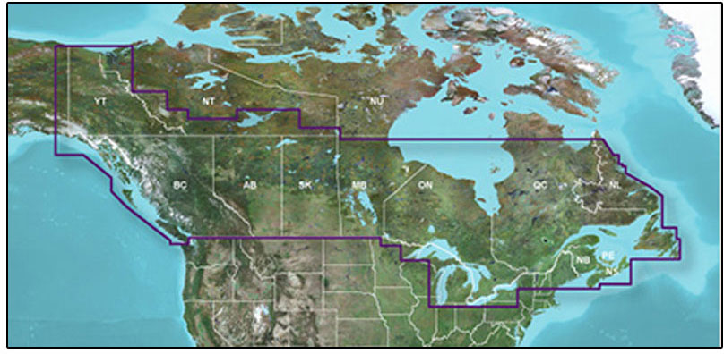
The Garmin LCA100F LakeVu HD g3 is an advanced freshwater fishing map that offers industry-leading coverage, clarity, and detail. It includes updated inland maps with integrated Garmin and Navionics content, providing a comprehensive view of more than 13,500 total lakes in Canada.
One of the key features of this fishing map is the Auto Guidance¹ technology, which quickly calculates a suggested route based on your desired depth and overhead clearance. This can be useful for both fishing and cruising, as it helps you navigate safely and efficiently.
Additionally, the LCA100F LakeVu HD g3 includes Depth Range Shading, allowing you to view your target depth at a glance. You can customize up to 10 depth ranges and see high-resolution shading for each range.
Another helpful feature is the Shallow Water Shading, which provides a clear picture of shallow waters to avoid. You can set a user-defined depth for shading, helping you navigate in areas with potential hazards.
To access your charts and maps, you can download the ActiveCaptain app. This app allows you to use OneChart, which gives you access to all your charts and maps from your mobile device. You can also purchase new charts and maps through the app.
It's important to note that the Auto Guidance feature is for planning purposes only and should not replace safe navigation practices. Please use caution and follow proper navigation protocols when using this fishing map.
Please be aware that this product may expose you to chemicals known to the State of California to cause cancer, birth defects, or other reproductive harm. For more information, please visit P65Warnings.ca.gov.
Frequently Asked Questions
1. Can I use this fishing map for both navigation and fishing?
Yes, the Garmin LCA100F LakeVu HD g3 is designed to assist with both navigation and fishing. The Auto Guidance¹ technology helps you plan your route based on desired depth and overhead clearance, while features like Depth Range Shading and Shallow Water Shading provide valuable information for fishing and navigation.
2. How many lakes are covered in the Canada LakeVü HD g3?
The Canada LakeVü HD g3 provides coverage for over 13,500 lakes in Canada, giving you a comprehensive view of the inland waterways.
3. Can I customize the depth ranges for the Depth Range Shading feature?
Yes, you can customize up to 10 depth ranges and see high-resolution shading for each range, allowing you to easily view your desired target depths.
4. How can I access my charts and maps?
You can download the ActiveCaptain app, which allows you to use the OneChart feature. This feature gives you access to all your charts and maps from your mobile device. You can also purchase new charts and maps through the app.
5. Is the Auto Guidance feature a replacement for safe navigation practices?
No, the Auto Guidance feature is for planning purposes only and should not replace safe navigation practices. It is important to use caution and follow proper navigation protocols when using this fishing map.




Ivy –
Rosita –
Lisa –
Tramaine –
Princeton –
Shayne –