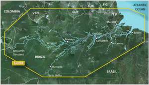
The Garmin VSA009R G2 Vision for Amazon River – Micro SD is an advanced navigation tool designed specifically for mariners and boaters traversing the complex Amazon River system. This device offers a suite of features designed to enhance maritime navigation, safety, and fishing endeavors.
Features of Garmin VSA009R G2 Vision
The device's extensive array of features includes:
- BlueChart g2 Technology: Detailed maritime charts provide accurate navigational data and improve situational awareness.
- 3-D Perspective View: Offers a realistic, three-dimensional representation of your surroundings on the water, aiding in navigation.
- Auto Guidance: Algorithm-driven route suggestions tailored to your vessel's size and capabilities, navigating around obstacles when possible.
- High-Resolution Imagery: Helps with visual navigation by providing clear aerial photographs of ports, marinas, waterways, and landmarks.
- Navigational Aids: Includes a comprehensive set of aids such as navaids, port plans, and various symbols adhering to IALA standards.
- Smooth Display: Ensures map details and satellite images are presented with minimal on-screen clutter, allowing for clearer decision-making.
- MarinerEye View: Offers a top-down view of nautical charts, ideal for planning and navigation.
- FishEye View: Provides an underwater perspective, helping to understand the seabed landscape for fishing and diving activities.
- Safety Shading: Enables users to apply shading to standard depth contours for a quick visual indicator of shallow water.
- Fishing Charts: Includes detailed charts to assist anglers in locating fishing areas by highlighting underwater contours and depths.
- HomePort Compatibility: Compatible with Garmin's trip-planning software, HomePort, allowing for careful and efficient trip organization.
Frequently Asked Questions
Is the Garmin VSA009R G2 Vision for Amazon River – Micro SD compatible with all Garmin devices?
No, it is specifically optimized for certain Garmin chartplotters and multifunctional displays, and compatibility should be checked prior to purchase.
Can I update the charts and maps on this navigation device?
Yes, Garmin provides periodic updates which can be accessed through their official website, ensuring you have the most current navigation data.
How accurate are the high-resolution satellite images included in this device?
The images are typically very accurate, but mariners should be aware that conditions change, and real-time variations may not be reflected in the static imagery.
Can I use this device for fishing?
Absolutely, the included fishing charts are designed to enhance the fishing experience by helping users identify promising fishing locations.
Does this device come with a warranty?
Garmin provides a limited warranty for their products, and you can learn more about coverage and duration by visiting Garmin's warranty information page or consulting product documentation.
This Garmin Micro SD card for the Amazon River region is an essential tool for serious boaters looking to navigate these waters with precision and safety, offering an impressive suite of features to aid in navigation, planning, and fishing activities.




Clara –
Alix –
Keri –
Virgil –
Hazel –
Shannel –
Iris –