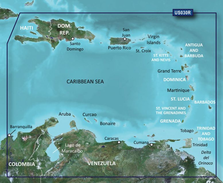
The Garmin VUS030R BlueChart g2 Vision HD – Southeast Caribbean is an advanced marine navigation chart that offers comprehensive coverage and sophisticated features to enhance your boating experience in the Southeast Caribbean region. Suitable for sailors, fishermen, and maritime enthusiasts, this chartplotter boosts your confidence when navigating the pristine but sometimes challenging waters of the Caribbean Sea.
This high-definition marine chart covers an extensive area, important for anyone traveling around the Caribbean. Notable areas include popular destinations like Haiti, Trinidad and Tobago, Puerto Rico, and the plethora of islands known as the Lesser Antilles. Nautical navigators will also benefit from the detailed coastal charts of Colombia and Venezuela, including critical spots like Barranquilla, the Orinoco River delta, Lake Maracaibo, and the Gulf of Paria.
Key features of the Garmin VUS030R BlueChart g2 Vision HD include:
– Navigational aids that provide crucial information to help you navigate safely.
– Spot soundings and depth contours to understand the water's depth and underwater topography.
– Precise details on tides and currents to plan the best times for travel and fishing activities.
– Information on ports and marinas, offering a clearer understanding of docking spots and amenities available.
– The Garmin Auto Guidance technology that calculates a proposed path for your journey based on boat specifications and chart data.
Garmin's advanced features, such as MarinerEye and FishEye views, give you three-dimensional images above and below the waterline, which can be particularly useful for those who fish or want to understand the topography of the seafloor for anchoring or diving activities.
For enhanced situational awareness, the high-resolution satellite imagery provides crystal-clear visuals of ports, marinas, bridges, and navigational markers. This can greatly assist with docking and transit through congested areas or when approaching unfamiliar harbors.
It is essential for users to exercise caution and recognize that features like Auto Guidance are supplementary tools. Mariners should always ensure they follow safe navigation practices and are not solely reliant on automated systems.
Frequently Asked Questions:
1. Can I use this chart package on any Garmin navigation device?
While the Garmin VUS030R BlueChart g2 Vision HD – Southeast Caribbean is compatible with many Garmin chartplotters and multifunction displays, it's important to check the compatibility with your specific model before purchase.
2. Does this package include information about tides and currents?
It contains comprehensive tidal and current prediction data, crucial for effective journey planning in the maritime environment.
3. How does the Garmin Auto Guidance technology work?
Garmin Auto Guidance technology processes your boat's parameters and the chart data to suggest the optimal route to your destination, highlighting the safest navigational path based on your specified depth preferences.
4. Can I view high-resolution satellite imagery of ports and marinas?
Indeed, this feature allows you to visually cross-reference nautical charts with real-world images, facilitating precise navigation and docking.
5. Does this package provide a 3D depiction of the ocean bottom?
Absolutely, the 3D views deliver an underwater perspective that can help mariners to avoid potential hazards and locate fishing grounds or dive sites more effectively.
This marine cartography product offered by Garmin is an invaluable tool that contributes to a safer and more enjoyable maritime navigation experience in the Southeast Caribbean. It blends traditional charting with modern technology to cater to the demands of today's boaters.





Carolina –
Velvet –
Michale –
Bryana –
Josie –
Larisa –