The Garmin VUS513L BlueChart g3 Vision HD is an advanced maritime navigation chart designed to provide boaters and fishermen with precise and comprehensive coverage of coastal and offshore waters. As boaters demand more accurate and up-to-date information, Garmin's BlueChart g3 Vision HD series caters to that need, incorporating the latest mapping technologies.
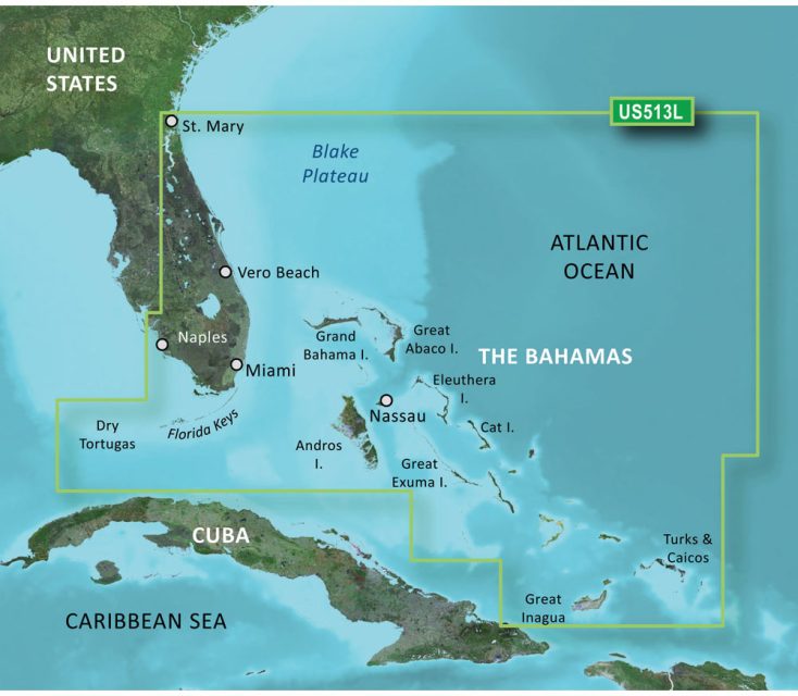
Travel with confidence through the waterways of the Florida Peninsula with detailed attention to critical areas like the St. Johns River, Crescent Lake, Lake George, Lake Monroe, and others. This product offers an unparalleled guide for navigating these waters, whether you're planning a fishing trip, sailing, or cruising to your favorite coastal destinations.
The BlueChart g3 Vision HD navigation chart enables you to see the world below the waves with stunning clarity, owing to features like integrated Garmin and Navionics data. The chart promises an improved marine experience with its beneficial Auto Guidance technology that can automatically suggest the best routes based on your boat's specifications.
One of the most prominent features to note is the high-resolution relief shading that provides a life-like view of the ocean floor, aiding in better situational understanding and safe operation in unfamiliar waters. This technology is especially crucial for deep-sea fishermen and divers looking for specific underwater structures. With the addition of depth range shading, shallow water shading, and high-resolution satellite imagery, the Garmin VUS513L BlueChart g3 Vision HD is a must-have tool for any serious mariner.
The high level of detail and broad area coverage make this chart a valuable asset for seafarers voyaging across the tropical paradises of the Florida Keys, the Bahamas, and the Turks and Caicos Islands. It's an essential travel companion, ensuring that you're well-prepared for the adventures ahead.
Maximizing Your Marine Experience with Frequently Asked Questions
How should I utilize the BlueChart g3 Vision HD for my marine journeys?
The BlueChart g3 Vision HD is a top-tier planning tool intended to complement your existing onboard navigation systems. While it should not be the primary means of navigation, it can significantly enhance your pre-voyage preparations and situational awareness.
Is it possible to integrate the BlueChart g3 Vision HD with Garmin echomap series?
The BlueChart g3 Vision HD cannot be displayed on certain devices, like the echoMAP CHIRP or ECHOMAP Plus. However, it's fully viewable and versatile when accessed through mobile devices using the ActiveCaptain mobile app, ensuring you have the information you need, wherever you are.
What functionalities does the BlueChart g3 Vision HD provide?
With a focus on accuracy and detail, the BlueChart g3 Vision HD offers an array of functionalities aimed at safe and informed navigation. It combines updated coastal charts, integral Garmin and Navionics content, innovative Auto Guidance, and various shading techniques to improve your understanding of water depth and bottom structure.
What regions can I explore with the BlueChart g3 Vision HD?
Boasting expansive coverage, the BlueChart g3 Vision HD includes significant locales within the Florida Peninsula and extends its detailed mapping to the idyllic cruising spots of the Florida Keys, the Bahamas, and the Turks and Caicos Islands, making it a versatile chart for many destinations.
Explore the seas with the Garmin VUS513L BlueChart g3 Vision HD, and let the most detailed and intuitive marine charts guide you on your next maritime adventure.




Chimere –
Shelly –
Venessa –