

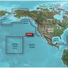
The Garmin HXUS604x BlueChart g3 HD is a microSD/SD card chart that provides detailed coverage of coastal areas in the United States and Canada. The coverage includes the East Coast from Key West, Florida, to the Canadian border, the West Coast from Puget Sound to the Mexican border, Alaska, Hawaii, important interior rivers, the United States Gulf Coast up to the Mexican border, and the Mexican Gulf Coast up to the Yucatan Peninsula. In Canada, the whole St. Lawrence Seaway, Nova Scotia, and New Brunswick are covered. The Great Lakes and Lake of the Woods are also covered in the product.
The BlueChart g3 coastal charts feature revised coastal charts that integrate Garmin and Navionics data. They provide industry-leading coverage, clarity, and detail. The Auto Guidance technology is an exciting feature that allows the chart to determine a path based on the desired depth and overhead clearance and recommends a suitable course to follow. Additionally, the BlueChart g3 has depth range shading for up to 10 depth ranges, up to 1′ contours for precise bottom structure visualization, and NOAA raster cartography that allows chartplotter paper chartlike views of NOAA-surveyed regions.
It is important to note that the Auto Guidance tool is for planning purposes only and cannot substitute safe navigation operations. The BlueChart g3 contains precise contours, shallow water shading, and NOAA raster cartography that offers chartplotter paper chartlike representations of NOAA-surveyed regions.
Consumers are cautioned that the product may expose them to chemicals that have been linked to cancer, birth defects, and other reproductive damage in California. For more information, refer to P65Warnings.ca.gov.
Frequently Asked Questions
1. How do I install the Garmin HXUS604x BlueChart g3 HD?
To install the Garmin HXUS604x BlueChart g3 HD, simply insert the microSD/SD card into a compatible chartplotter or multifunction display unit. Follow the manufacturer's instructions for inserting and navigating the chart on your device.
2. Can I use the BlueChart g3 charts on multiple devices?
Yes, you can use the BlueChart g3 charts on multiple devices as long as they support microSD/SD card compatibility. Simply remove the card from one device and insert it into another compatible device to access the charts.
3. Does the Auto Guidance feature provide real-time navigation?
No, the Auto Guidance feature on the BlueChart g3 is for planning purposes only. It helps to determine a suitable course based on desired depth and overhead clearance, but it does not provide real-time navigation. Safe navigation operations should always be followed while using the charts.
4. Are the charts compatible with both Garmin and Navionics devices?
Yes, the BlueChart g3 charts integrate Garmin and Navionics data, making them compatible with both Garmin and Navionics devices. You can enjoy the industry-leading coverage, clarity, and detail on either brand's compatible devices.
5. Is the BlueChart g3 compatible with Mac and Windows operating systems?
Yes, the BlueChart g3 is compatible with both Mac and Windows operating systems. You can use the charts with supported chartplotter or multifunction display units that are compatible with your computer's operating system.


Lanette –
Laquandra –
Latonya –
Irwin –